This is at a place called Furnace Creek, and you can see why it is called that with this picture.

It wasn't even noon yet and still May and it was already this temp. I took some video of a view from that location. My intent was to show the heat waves on the Playa (the sometimes wet floor of the valley), and the snow on the mountain in the background.
The Peak in the background is Telescope Peak, the top is at 11,043' it says in the link.
Considering the fact that just down the road to the left in the video is a place called Bad Water that sits at -282', that is below sea level, and those two points are about 15 miles apart that is a very health rise in altitude.
There is a resort here, The Furnace Creek Inn, looking back at my thermometer I think this is a winter resort...lol

We Drove a mile down the road to Furnace Creek Proper, passing the Timbisha Indian Reservation. Those Indians have been there thousands of years living in a place we find a waste land. Interesting how versatile, and adaptable humans are. We found a National Park Museum there and went in. Very interesting stuff about Death Valley, the local animals and inhabitants, the poor immigrant wagon trains that made it into the area and almost melted there, and the Silver and Borite mines, and the Twenty Mule Teams pulling ore out of the Valley.
I think the story went that one of the wagon trains that was stuck there for a while, when they finally left, someone looked back and said "good bye Death Valley" and it stuck. We stopped at a place that was like a Trading Post, mostly filled with Tourist stuff and cool western and indian art things. We had to start making our way home soon so we started towards Bad Water Basin, the lowest point in the US. We travel down the road and came across this weird weathered black rock.

We are notorious rock hounds, and the cute fiancee wanted me to put it in the back of the truck.
There were signs for a place called "Artist's Drive", so when the sign said turn left we did.

As you can see from these pictures there is all these reds, greens, yellows, blacks, whites, and even purple in the rocks.


It was a very nice natural display. It was very hot and the truck temp gauge kept climbing. (I think the thermostatically controlled fan is turning on at the wrong time or is going bad, must fix before next summer...lol) I would turn off the AC and we would drive uncomfortably for a while then turn the AC back on and keep and eye on it until it got warm again. On our way out cute fiancee spotted this cool rock formation. I think I would title this picture "Frog on a Frogs back".
What do you think.?

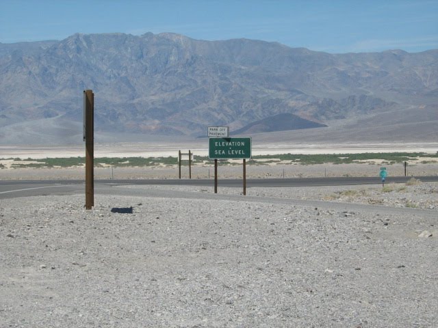
We finally came to Bad Water Basin. The temp had gone up to about 105 by then and the cute fiancee wanted nothing to do with that.

There was a breeze when I got down to this sign. It was like a wave of heat hitting you when you open a hot oven. Brave tourist from car, buses, and motor homes were walking out onto the playa. What a moon scape.

There is water that seeps from out of the ground and collects into these brackish pools.

The water evaporates and leaves the ribbons of salt (shown above in the moon scape).
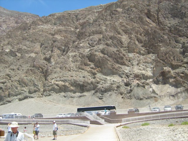
The name at this place says it all. Lots of water but none that would be drinkable. I walked a little way out onto the playa. Out there was a load of Asian tourist off the bus that was in the parking lot. They looked like they were going to melt. I took a picture of the hill that backed up to this place.
There is a sign on this hill, not that it is big enough to see in a pic like this, so as to get perspective. Off the back of the bus, slightly under the half way mark is a black sign with white letters that says, SEA LEVEL.
We started down the road a ways and came to a road sign. It was a good place to eat the sandwiches we brought. The sign was about an ancient lake that once filled Death Valley.
It was named Lake Manly, after one of the gentleman that hiked out of Death Valley around 1849 when his wagon train that got stuck down in the Valley. He went all the way to the LA Basin to find help. Some geologist named it that after looking at this formation that is now called Shoreline Butte.

If you notice this butte has a kind of layered look to it. 15,000 years ago, during the last Ice Age, water filled Death Valley. As a matter of fact what is now a arid desert was at this time chocked full of lakes, most of them eventually draining into Death Valley. If you follow the Lake Manly link above there is a map of what all those lake looked like. If you look at a map and follow the course of the Mojave River which has it's head waters in the San Bernardino Mountains, near Lake Arrowhead, you can see that if water actually flowed in the Mojave it would go all the way to Death Valley, after puddling a couple of times near Baker Ca.
From hear we navigated out of Death Valley, out through Baker, and headed home. It was a great adventure. There is more out there to see, and I hope we can get out there again this winter. There are Borax mines to see, Scotty's Castle, and a place called Racetrack Playa, where rocks appear to move all by themselves.
No comments:
Post a Comment